


Flight Explorer Shows American Airlines 'Flight 77' Did Not Turn Around At Kentucky & Ohio Boarder On CNN News Sept 11th

Evidence shows that AA77 did not turn around on the Kentucky and Ohio boarder like we are led to believe and head back to Washington to crash into the Pentagon on Sept 11th 2001. Other supporting evidence shows this also, showing that it flew over Missouri.
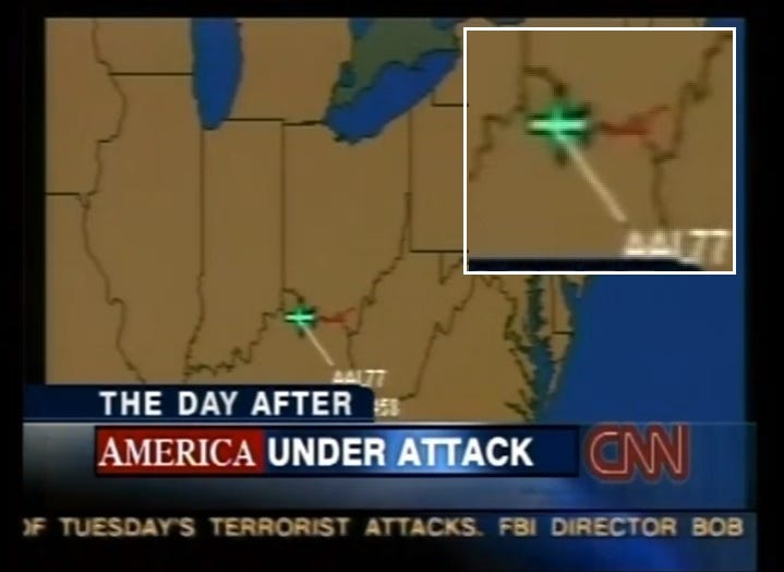
CNN showed the real-time Flight Explorer flight path location of AA77, showing the plane was transmitting its positional location. Meaning the transponder was on. This now indicates that the black box data flight path study could not have been from AA77's flight path, which could go some way to explaining the discrepancies in the flight path study its self as presented by NTSB.
AA77's "official" DCC Radar Flight Path Evidence (Visual Study)
In this video I discuss American Airlines Flight 77's "official" DCC Radar flight path, using the "official" radar evidence which was obtained under a Freedom of Information Act. (FOIA). The DCC Radar data has not been seen by the public until its release. The DCC radar data coordinates were very different to the Rades84 coordinates, which is a major conflict for the "official" narrative. The DCC Radar evidence is also backed-up by FAA & NORAD communication recordings and transcripts, showing that AA77 did not turn around on the Kentucky OHIO boarder, and head back towards Washington, but continued in its flight path towards Falmouth, St Louis and Missouri and into Kansas, before heading back again towards Missouri and then back to Kansas and then disappearing off radar. Thank you all for your interest in my research.
Thanks for reading & watching! Please feel free to Subscribe.
As to where Flight 77 could've landed, one possible answer is airports near Centerville, Kansas - the closest being Fort Scott Municipal Airport at 50 miles, which you have to scroll down to find after you click the below website:
https://www.travelmath.com/nearest-airport/Centerville,+KS
Centerville, Kansas is where the last DCC coordinates for AA77 places the plane to be (latitude: 38.233, longitude: -95.07). You can place the numbers below to confirm this yourself:
https://latlongdata.com/latitude-longitude-lookup/
The above coordinates came from this document, which I believe you have in one of your posts on Flight 77:
https://catalog.archives.gov/id/7595913
The coordinates for Fort Scott Municipal Airport are 37.795 latitude, -94.76 longitude.
To provide additional corroboration of AA77 flying further west towards Missouri and Kansas, some mainstream publications such as the San Francisco Gate and the Detroit News has illustrations depicting the plane doing just that. Here are some examples below:
https://web.archive.org/web/20141011082002/http://www.sfgate.com/news/article/INVESTIGATING-9-11-THE-HIJACKINGS-2706265.php#photo-2169574
https://web.archive.org/web/20131214152543/http://www.911omissionreport.com/flight_77_flight_path/flight1.gif
You can use these illustrations for any article you have on Flight 77 such this one. Take care.