


Withheld Official DCC Radar Data & Flight Explorer Evidence, Proves United 175 Was Still Airborne At 9:07 AM
An Independent Investigation

Introduction
I am revisiting the United 175 (UAL 175) Flight Explorer evidence which was shown live on MSNBC at 10:25 a.m., which showed UAL 175 was still airborne after it allegedly crashed at 9:03 a.m. into the South Tower. See below:
See below: Screen Shot from MSNBC Flight Explorer, showing UAL 175 over Connecticut.
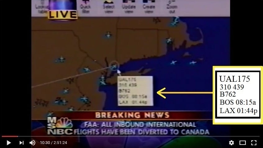
The Flight Explorer MSNBC evidence locates UAL 175 flying over Connecticut, however, it has never been determined the precise time that UAL 175 was flying over Connecticut, which was shown in the Flight Explorer evidence.
The information that has been obtained, now reveals the precise time UAL 175 was flying over Connecticut, and according to the withheld DCC Radar data, which was only released under a freedom of information, it gives precise Lat-Long coordinates of UAL 175 at 13:07, which is 9:07 a.m. EST, which is 4 minutes after UAL 175 had allegedly crashed into the South Tower at 9:03 a.m. See below:

UAL 175 - (d) Radar - 4 DCC 1737 Radar Track Data UAL175 Radar Track.pdf
Source: https://catalog.archives.gov/id/7598281
Below, shows Google Earth with plotted of UAL 175’s official DCC Radar Lat-Long coordinates, which places UAL 175 over Connecticut at 9:07 a.m.
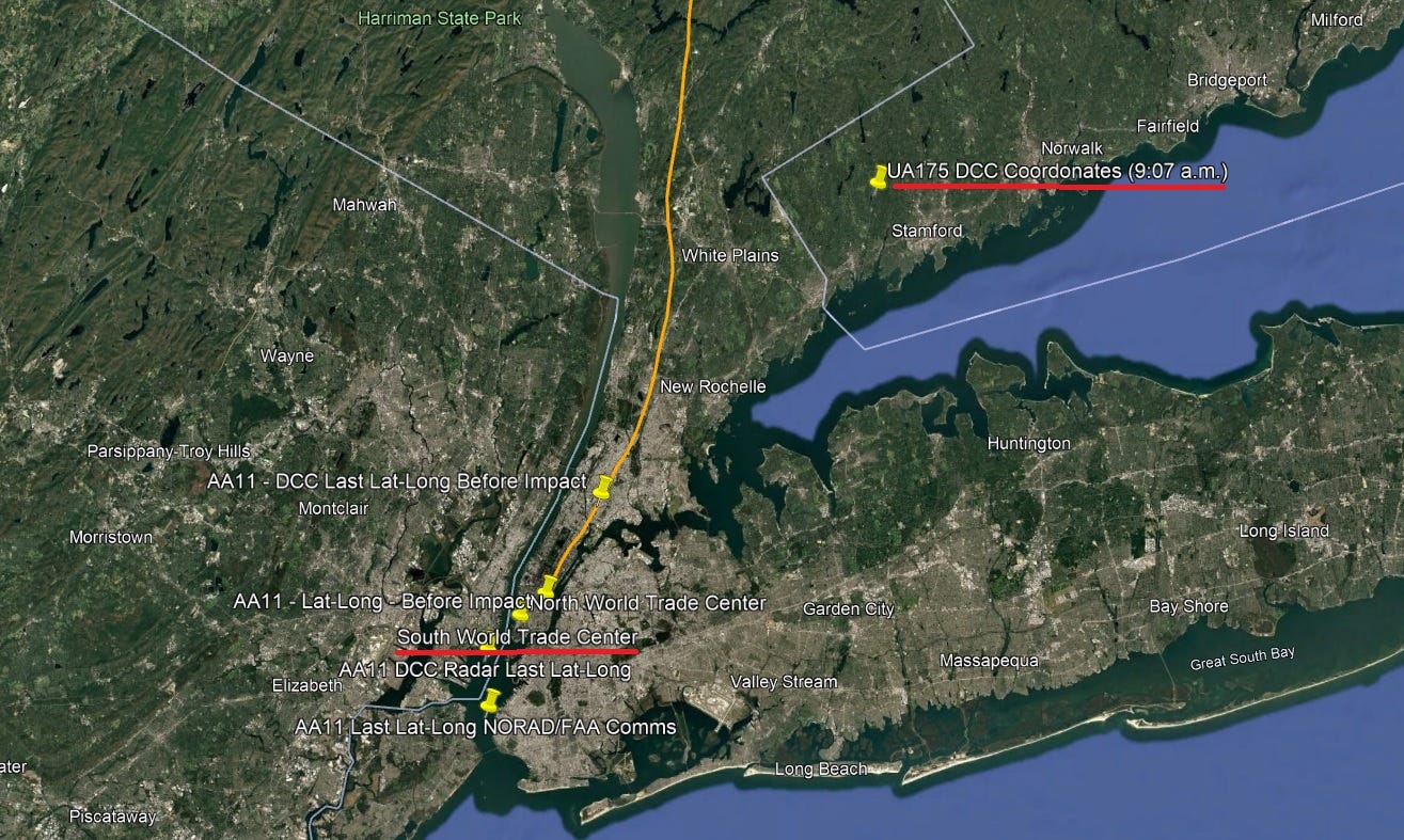
Below, shows the MSNBC Flight Explorer evidence inset (highlighted yellow box) and plotted DCC Radar coordinate UAL 175 location on Google Earth, for comparison.

Also revealing is, the DCC Radar data, which correlates with UAL 175’s precise altitude, which is 31,000ft.
Also, researcher Jane Cena discovered another version of the Flight Explorer animation, which corroborates both the MSNBC and DCC radar versions, showing the plane turning around over New Jersey, speeding past New York, and flying above Connecticut. See below, screen-shot, and animation GIF.

Moreover, Jane Cena notes that both the MSNBC version and the GIF version which Jane discovered shows that Flight 175 was at 31,000ft in altitude and also traveling at 439 mph when it flew into Connecticut. Jane believes this confirms that we're looking at the same animation provided by Flight Explorer.

Source: http://smoking-guns.info/images/Feual175anim.gif
Concluding
So the Flight Explorer evidence correlates with the official DCC radar data, not only showing UAL 175 flying past the South Tower and still airborne at 9:07 a.m., which is 4 minutes after it was alleged to have crashed, but also travelling at 31,000ft, which implies, that UAL 175 did not descend and crash into the South Tower.
This also now resolves that even though the Flight Explorer evidence was shown on MSNBC at 10:25 a.m., in reality, the actual Flight Explorer data, was from 9:07 a.m.
Again, this is more supportive evidence that UAL 175 was not the plane that crashed into the South Tower, which indicates as to why the authorities withheld the radar data because of how damming it was for the official narrative of UAL 175.
I would like to credit and thank researcher Jane Cena for her input and information, which she has shared with me, which has helped in the writing of this article.
Thanks for reading & caring.
BTW, the last DCC lat/long coordinates for UA175, which places it over Cos Cob, CT, is 25 miles in flight distance from Manhattan, NY. That's even greater than the distance AA11 flew past the WTC according to the DCC radar and NORAD.
https://www.distancesfrom.com/us/flight-distance-from-Manhattan-to-Cos-Cob-Greenwich/FlightHistory/42179068.aspx
Not to mention that like I said previously, another version of the Flight Explorer animation also corroborates both the MSNBC and DCC radar versions, showing the plane turning around over New Jersey, speeding past New York, and flying above Connecticut. You can use this in your article, too:
http://smoking-guns.info/images/Feual175anim.gif